Q&A
Tom Hegen
Looking at the Anthropocene from above.
PHOTOS Tom Hegen
Tom Hegen is a photographer and designer based in Munich, Germany, with an interest in the relationship between humans and nature. His aerial photographs depict landscapes that have been heavily transformed by human intervention to raise awareness about the extraordinary forces impacting our environment.
What ignited your interest in photography?
It all started in 2015 when I visited an exhibit on the ”Anthropocene,” a term that had been proposed by a board of scientists as a label for a new human area. Scientists around the world recognize that we as humans have had such a huge impact on the geological, ecological, and atmospheric processes on earth that we have become the most impacting force on our planet. I wanted to examine this topic through my visual language to start drawing attention to environmentally relevant issues and, hopefully, inspire people to make a difference for our planet. I also started to question the idea of “landscape” in the expression “landscape photography.” ”Land” is a word of Germanic origin and the roots of the suffix “-scape” (from the German -schaffen) refer to the verb “to shape.” So landscape in the sense of “landscaping” refers to an activity that modifies the visible features of an area. As a consequence of that, I started seeing landscape photography as a way of documenting land that has been influenced by humans rather than as depicting pure, unspoiled nature.
How do you choose your topics?
I mainly focus on environments that have been massively transformed by human intervention. But I also try to find a certain beauty in such places. I see my work as an aerial photographer as photojournalism with a high degree of abstraction. I use abstraction and aesthetics in my work to draw attention to environmental issues. Presenting something in an abstract way often provides a different perspective on ordinary topics. I also give my viewers background information, so they get some educational insight from what they have seen. The photos can be the delicious appetizer to a not so tasty main dish.
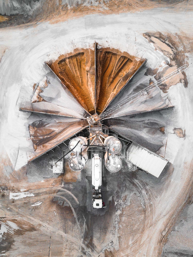
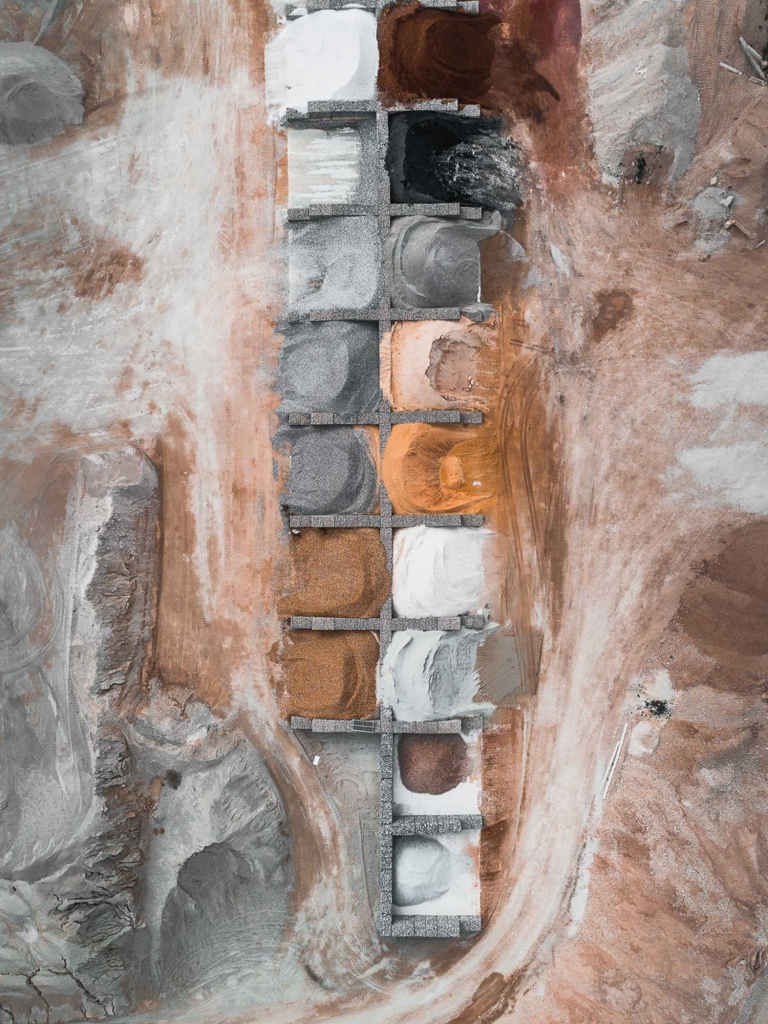
Above a gravel mining pit in Germany, The Quarry Series shows the beauty of open-pit mines. A massive amount of raw materials are needed for the construction of growing cities and infrastructure. To meet the demand for raw materials, we have developed various methods for both mining them and processing them once they’re out of the ground.
You’ve photographed quite distinctive landscapes. What series are you most proud of and why?
Last year I went to the Arctic and did a project on the effects of global warming on the artic ice pack. The resulting project, Two Degrees Celsius, shows meltwater, rivers, and lakes on the arctic sea cover, a phenomenon caused primarily by man-made global warming. Greenland and the Arctic are such remote places that it’s alarming to realize we have impacted even environments with hardly any human habitation. Seeing and experiencing this from above was quite a profound feeling.
Has the rise of drone photography influenced your work in any way?
Aerial photography is now a democratic genre due to the invention of drone technology. Nowadays, drones are very competent and they are approaching the same quality of camera cranes and helicopters. But for me, they are just tools. I do use drones for some of my aerial projects. My first quadcopter was self-built and I attached a camera underneath to take my first aerial photos. Today, I use a mix of tools from Helicopters, small aeroplanes, hot-air balloons, or drones. I have even done projects from the top of a bridge. I focus on single images, series, the concepts rather than technique.
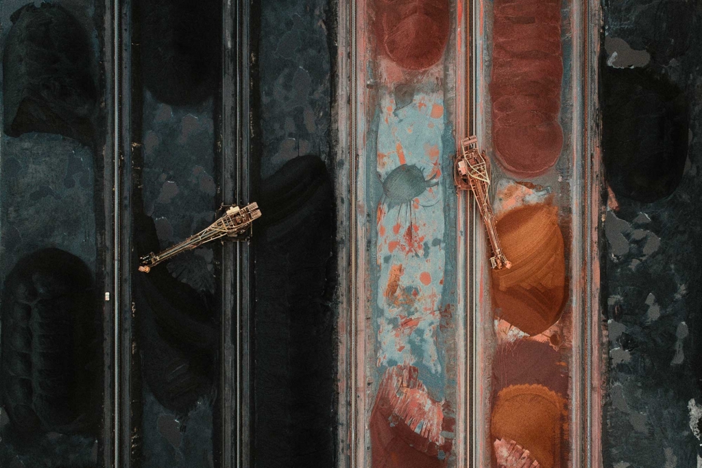
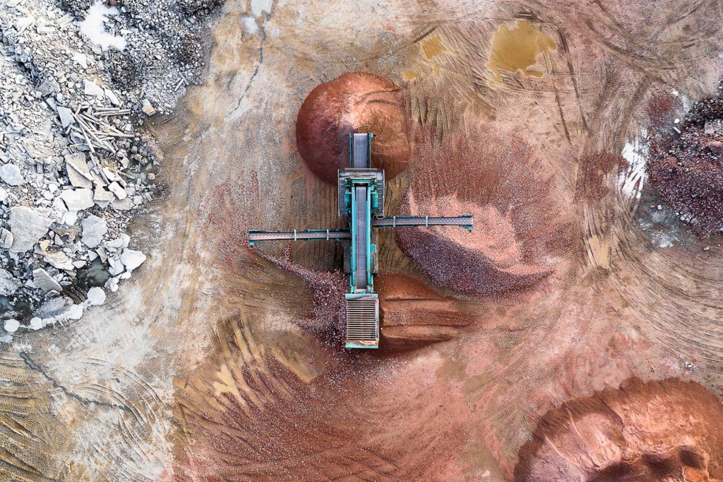
Besides oil, lignite is one of the world’s main energy sources. Energy production from coal has enabled our civilization to make significant economic and social progress, but it also represents one of our most significant ecological problems: Burning fossil fuels contributes significantly to global warming.
Looking at your aerial views of nature, we see both beauty and disruption. What can we learn from looking at those landscapes from above? How do you feel when you are up there?
Aerial photography provides two specific advantages: an overview and insight. It simply enables us to see things that wouldn’t be visible from the ground — a forest, for example. From the ground, it may look like pristine nature. Once you change the perspective and get an overview, you recognize that every single tree is planted in the form of a grid to make it easier to cut rows. Aerial photography shows the connection between its subjects and their environment, and on a much larger scale.
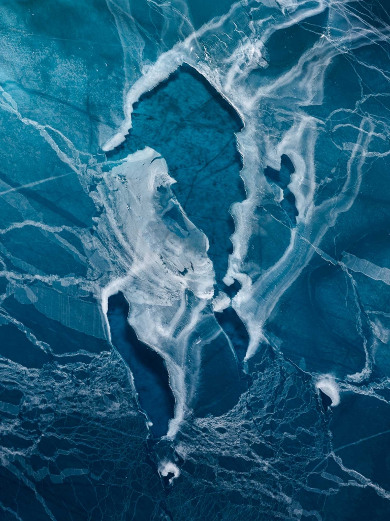
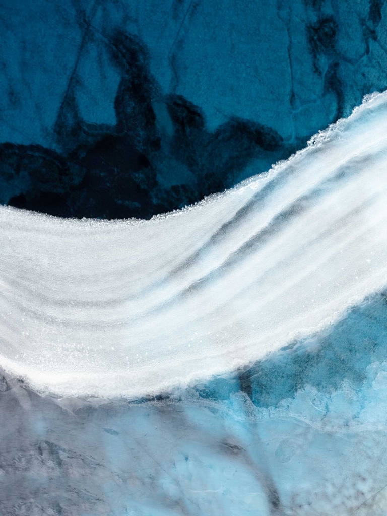
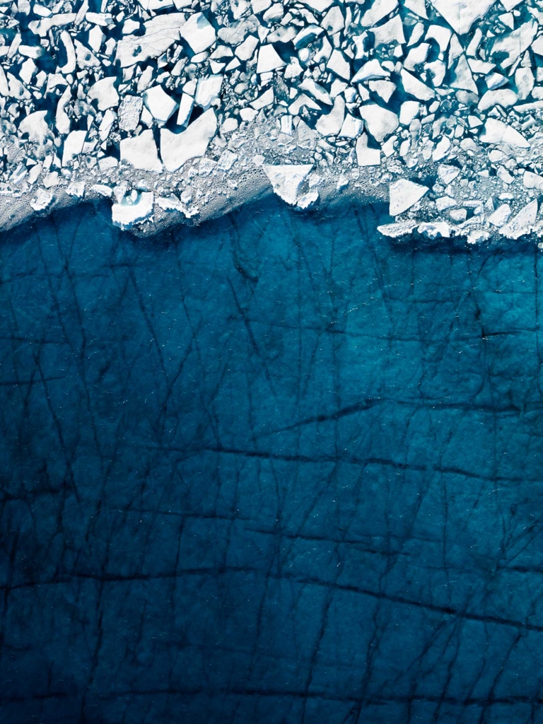

In the 2015 Paris climate accords, 197 countries agreed to keep global temperatures to below two degrees Celsius above pre-industrial levels, in an effort to avoid the disastrous consequences of climate change. However, average surface temperatures across the globe have already risen by one degree Celsius since pre-industrial times (1880), meaning that we’re already halfway to the threshold we’re trying to avoid. So what do the effects of this warming look like exactly? The Two Degrees Celsius series explores the impact of global warming on the arctic ice pack, which causes meltwater, rivers, and lakes to form on the arctic ice cover.
Have you ever had any surprises, good or bad, photographing an area from above?
A lot of my work is carefully planned in advance. Before getting up in the air, I have quite an exact idea in mind of what I would like to photograph. Preparation is crucial when it comes to aerial photography. It helps for a safe and successful aerial production. I basically work with a four-step-method of research, conceptualization, execution, and evaluation. I try to minimize the number of surprises but I always leave space for situations that can lead to unexpected results.
Do you see similarities and/or differences between human-made (e.g., farmland) and nature-made (e.g., craters) patterns?
Our drive to discover, explore, acquire, and interpret the world leads to some artificial landscapes. It seems that we as humans need to lay out everything in measurable shapes to better control our environment, whereas nature is more fluid, rhythmic even, and more organic.

These abstract landscapes are the consequences of coal mining. Mining lignite from the ground reduces groundwater and brings it along with oxygen into contact minerals such as pyrite or marcasite. The result in iron hydroxide and sulfate, which lead to the water’s discoloration.
Are you involved in any specific cause or social initiative that you would like to tell us more about?
I have actually started working on a concept for a second book project that will feature social grievances in the context of environmental problems. In this way, I hope to raise awareness of social and environmentally relevant issues and move the dial in some way.
Name 3 Instagram accounts that inspire you.
1- @geosteinmetz
2- @ante
3- @itsreuben
____
Find Tom Hegen